
WTF: SS Wear or What?
Is the shipwreck WTF actually SS Wear? I believe so, here’s why…
Identifying any wreck in 125m can be difficult, but the history behind the shipwreck named “What the Fuck” or WTF is confusing. Discovered by a Sydney Project team in 2006, the WW2 era wreck was originally identified as SS Iron Knight. Subsequent dives proved this to be incorrrect based on size and configuration, so the name WTF stuck. In more recent years, a case has also been made for it actually being SS Coast Farmer.
SS Wear sank almost immediately after a collision with SS Anatina, who radioed the message “PICKED UP SURVIVORS FROM SHIP IN COLLISISON WITH US BEARING 355° 9 MILES OFF MONTAGUE ISLAND”. Note the rather precise bearing of 355° rather than due north.
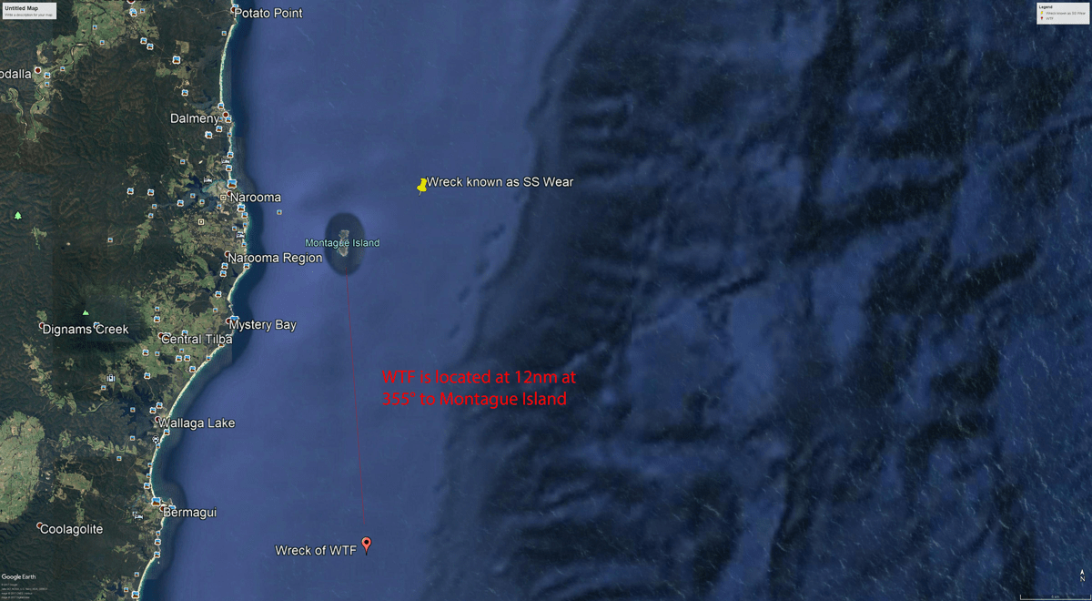
The wreck known as WTF is located at 36° 27.260’ S 150° 14.748’ E, which is exactly 355° off Montague Island, at a distance of 12nm. According to the NSW Heritage database, the shipwreck known as SS Wear is approximately 3.5nm north-east of Montague Island. Whilst the distance to Montague Island is 3nm out (25%), with such a precise bearing of 355° rather than due north, I fail to accept that the professional sailors on a non-sinking ship (i.e. MV Anatina) got being on the wrong side of Montague Island wrong.

One of the most prominent features of the WTF shipwreck is a large deck gun, which sits prominently on the aft deck. The records below shows clearly that SS Wear was fitted with a 12 Pounder HA/LA deck gun, with no such gun found on the wreck 3.5 NE of Montague. Additional citations from Australian government shipwrecks database also confirms SS Wear as “…reputedly armed with a DEMS gunner attached to the crew”, which is also confirmed in the crew manifest with a DEMS gunner listed as a role.

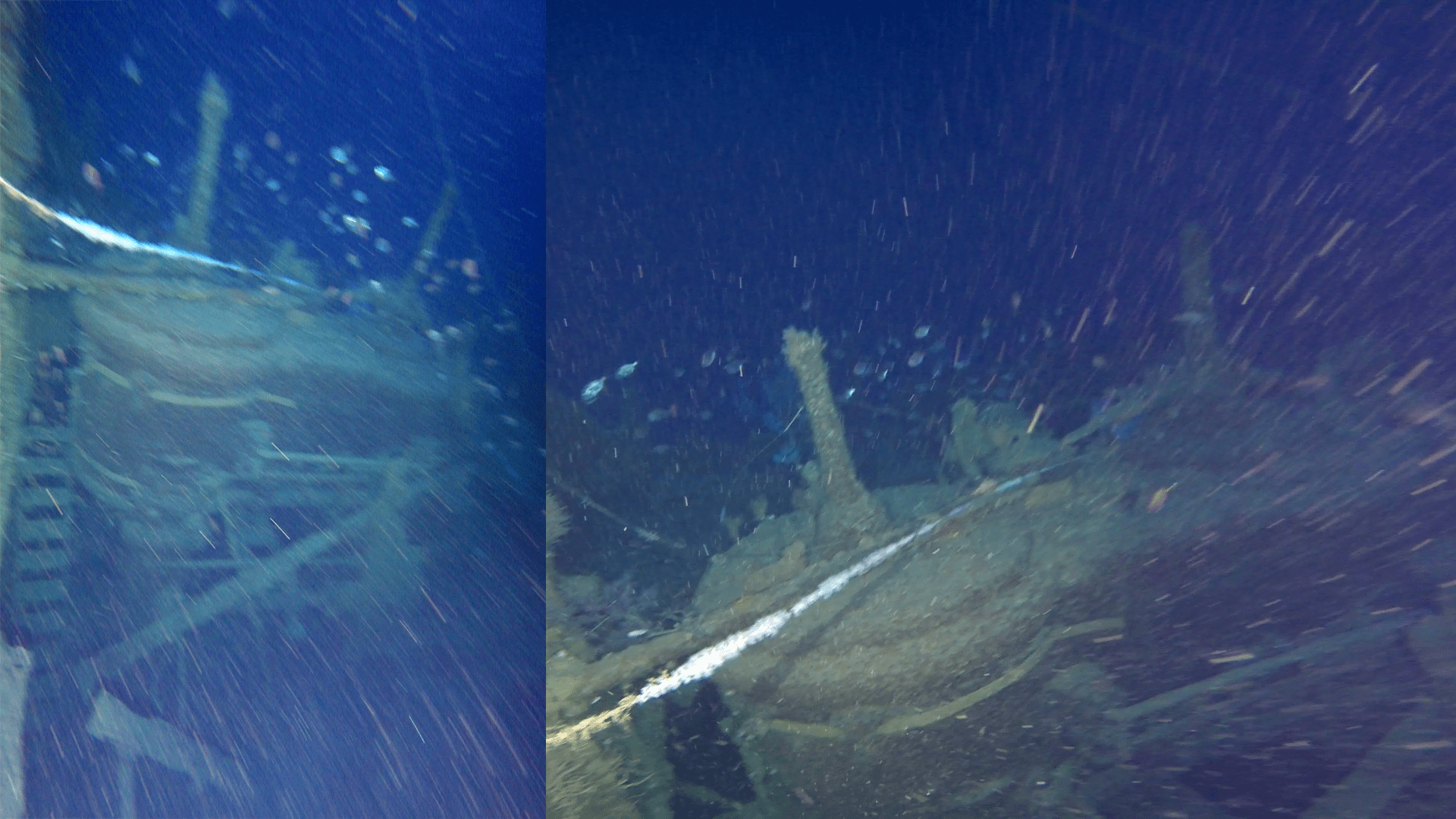
Additional analysis of footage from a recent WTF dive (see below), highlights additional points that reconcile to the ship’s plans of SS Wear.

- Stern – the rudder and counter stern profile closely match wear (see photo taken 9th July, Damien Siviero)
- Single Boiler – as per plans, the video shows single boiler centered in hull axis (timecode 15:04, bottom of frame)
- Arrangement – forward and rear cargo holds, centre bridge and engine room aft.
- Winches – forward and rear cargo holds both have steam winches, each with quad configuration
- Bathroom Basin – a bathroom basin (sink) is seen where Chief Officer’s bathroom is located on plans (timecode 07:40)
- Length – SS Wear had a length of 81.6m. Multibeam scans of WTF show a length of approximately 90m, albeit with a +/- 20m accuracy (4). Given the bow has collapsed and possible detached, accurate measurement here is likely impossible.
Video: Helmet cam footage, unedited, David Hurst – 09/07/2017
So what’s the shipwreck North-East of Montague (i.e. the one identified as SS Wear)?
Short answer – we don’t know, but there is evidence that it is not SS Wear.
First off, the shipwreck 3.5nm NE of Montague (36° 13.190’S 150° 17.400’E) has no 12 pounder deck gun, which SS Wear was armed with. The ship’s plans for SS Wear also confirm absolutely that it is powered by a triple expansion steam engine. Analysis of DPV mounted GoPro footage shot 2 years ago, shows a dual cylinder engine configuration (frame grabs below, also timecode 0:10 – 0:18, footage rolls sideways across engine). Combining these two factors, along with it’s position on the wrong side of Montague is sufficient to confirm that this wreck is not SS Wear.
And what about SS Coast Farmer?
All reports of the SS Coast Farmer were that it was sunk off Jervis Bay. Most notable of these are the tabular movement records of Japanese submarine I-11, which reports sinking SS George Livanos NE off Jervis Bay (roughly 35° 00’ S 151° 00’ E), and then 3 hours 41 minutes later logged the sinking of SS Coast Farmer SE off Jervis Bay (roughly 35° 23’ S 151° 00’ E). Whilst neither shipwreck’s location is known, survivors of the Livanos landed at Nowra which validates the Livanos’ appropriate sinking location – some 95nm from the WTF site. The I-Class submarines had a top surface speed of 18.7kn, so it’d be physically impossible for I-11 to be south of Montague Island in under 4 hours later and sink WTF. Best speed would have the sub travelling on the surface, which is improbable given it had just sunk the Livanos and/or was stalking Coast Farmer for another kill.
SS Coast Farmer was a also a dual boiler ship, however video of the WTF shows only a single boiler located on the centre line of the vessel. Historical photos of the Coast Farmer’s stern also do not match the profile of WTF.
Conclusion
I haven’t written this post to make a stir, I just think there is too much evidence to ignore and I am of the strong opinion that the WTF is in fact SS Wear. All respect to the guys that originally found the wreck and have subsequently put in effort to identify it – that’s huge. I’ve refrained from including anything in this post that “I think I recall from the dive”, instead relying only on photos, video and historic records that I can show and reference. I invite others to contribute to our analysis based on similar constraints, and will share any reasoned argument on this page.
Have I got it wrong? Well I hope not, but better to get this information out there and clear up a mistake (wherever that lies), than to have history recorded wrong.
I’d also like to reocognise Scott Willan from NSWWrecks.info for his contribution to this analysis and research.
Additional References
- Australian Navy, SS Wear Sinking Report, Australian National Archives, Pg3
- Australian Navy, WW2 Merchant Ship Records, File No. 63, Page 180
- Multibeam of WTF Site, CSIRO Southern Surveyor
- Illawarra Historical Society, World War 2 on East Coast of NSW, Japanese Submarine Attacks, Pg42
- Encyclopedia of Australian Shipwrecks, MV Anatina
- Southern Surveryor, Swath Data Summary, Pg13


